Orbital Mission Poised to Map Earth's Surface Water in Unprecedented Detail
Field report
A sophisticated radar satellite is set to reveal fresh details about the planet's water cycle and how shifting climates reshape freshwater ecosystems around the globe.
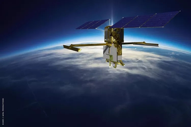
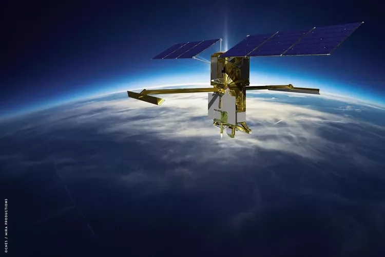
The Surface Water and Ocean Topography satellite lifted off from California in mid-December, opening an ambitious chapter in the study of rivers, lakes, and oceans from orbit.
Researchers involved with the project describe it as a turning point in Earth observation. One oceanographer likened the satellite's enhanced vision to slipping on a pair of spectacles after years of short-sightedness, with the planet's waters suddenly snapping into crisp, vivid focus.
Did you know?
The Earth's inner core is a solid ball of iron-nickel alloy about 1,220 km in radius, with a temperature comparable to the surface of the Sun.
Built over the better part of two decades through a partnership with the French National Centre for Space Studies, the spacecraft relies on advanced radar to track the height, spread, and flow of water across the globe. These measurements will deepen understanding of the global water cycle, clarify how warming temperatures reshape freshwater habitats, and equip communities with vital data for stewarding local water supplies.
Water, scientists note, must be managed across entire river basins rather than single points—whether for drinking supplies, navigation, or flood control. The mission is designed to deliver observations that span whole basins, giving planners the broad view they have long needed to care for shared freshwater resources.
Charting Nearly Every Freshwater Body on the Planet
One of the most striking facts behind the mission is how little scientists currently know about the world's freshwater. Researchers estimate that detailed records exist for only a few thousand lakes worldwide. The satellite is expected to measure and map roughly 95% of lakes larger than 15 acres and rivers wider than 330 feet, expanding that catalogue to somewhere between two million and six million distinct bodies of water.
By tracking the depth, spread, and surface area of nearly 1.3 million miles of rivers and lakes, the research team expects to gauge far more precisely how a warming climate is reshaping the planet's freshwater rhythms.
Rising oceans and shifting coastlines are already redrawing habitats around the globe, while inland lakes, reservoirs, and rivers swing through ever-larger fluctuations. Watching those changes from space offers scientists a clearer picture of how freshwater ecosystems respond to a warming world.
Amplified Views of Climate Impacts on Water
Oceans have absorbed more than 90% of the excess heat trapped by greenhouse gases. Much of that uptake is believed to happen around currents and eddies smaller than 60 miles across—features once too compact to study clearly from orbit. The new satellite sharpens resolution tenfold, bringing those hidden ocean dynamics into view for the first time.
Eddies and currents may drive up to half of the heat and carbon exchanged between surface waters and the deep ocean. By studying these swirling features in finer detail, scientists hope to determine how much more heat and carbon the ocean can absorb in the decades ahead.
A central question for climate scientists is when the ocean might stop absorbing heat and begin releasing it back into the atmosphere, accelerating warming rather than restraining it. The mission is designed to help answer one of the most pressing climate questions of our time.
Following a six-month calibration period, the satellite will settle into an orbit about 554 miles above Earth and begin its survey of surface water. The mapping cycle will repeat every 21 days, generating a continuous flow of data that will be made publicly available with tools for easier access. Although the mission is scheduled for three years, project leaders expect the spacecraft to keep watch over the planet's waters for far longer.
Engineers note that nothing in the spacecraft's design limits its operational life. Five years of service is considered well within reach, and decades of observation are entirely plausible based on the long performance of similar Earth-observation satellites.
Source: NASA Jet Propulsion Laboratory, "First Global Survey of Freshwater from Space," 2022.
Source: NASA Climate Change, "International Satellite to Track Small Ocean Currents," 2022.

References & Sources
- Primary source: https://www.treehugger.com/nasa-mission-map-earth-surface-water-6931077
- Regional reference: Siberian Traps geological survey.
- Cross-reference: Plate Puzzle archive, specimen GEO-392.
Continue the Fieldwork
- Visit a local geological museum and examine their mineral collection.
- Take a field notebook on your next hike and sketch the rock formations you see.
- Support organizations that protect fossil heritage sites from looting.
Specimen bookmarked for your next dig.